
“To the lover of wilderness, Alaska is one of the most wonderful
countries in the world.”
John
Muir
 |
| Creek Street |


The
Norwegian Star, a Dawn-class cruise ship pulled up to the dock of the
quaint town of Ketchikan, Alaska early on an overcast September
morning. The mist covered mountains accented the seaside homes that
lined the backs of the Tongass Narrows, which is a part of the
Southeast Alaska’s Inside Passage. The fishing boats were lined
up in the harbor, all ready to go out for the day. Ketchikan is
700 miles northwest of Seattle and about 235 miles to Juneau to the
north and is 5.9 square miles. This city is often called the “Gateway
to Southeast Alaska” since it is the southernmost city on the
Inside Passage. It was incorporated as a city in 1900 and has two
zip codes, one being the highest in the United States – 99950.


Ketchikan is an unusual name that the towns people really aren’t
sure were the name originated. One theory is that the word “Kitsch”
which is a Tlingit term meaning “the river belonging to Kitschk”
or may mean “Thundering Wings of an Eagle.” The term most likely
came from the Tlingits, who were Native American people who lived in
the Pacific Northwest Coast and were the first to inhabits the area
were Ketchikan is now located.


We
were excited to get off the cruise ship as we had a busy day ahead of
us. Our excursion for the day was to take a flight to fly over the
majestic Misty Fjords National Monument. We headed down Front
Street, amongst the crowds of vacationers scurrying to their
destinations for the day.


When
we arrived at the seaplane, we were kindly greeted, fitted with
special headphones, and told where we would sit in the plane. We
were lead down the ramp to the dock where the plane was located and
met our Bush Pilot, Steve. He was a nice fellow and explained what
we would be seeing and safety procedures. Afterwards, we were all
loaded into the plane, Joe sat in the front and I was in the rear of
the plane and we took off. I loved being in the rear as I was the
only one, so I could scoot from side to side to see all the sites.
 |
| Norwegian Star |


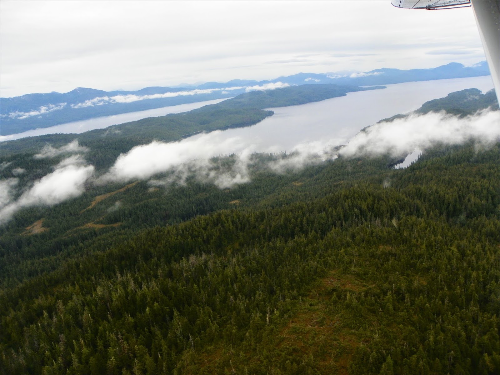
As
we left the harbor, we passed over our cruise ship and then the plane
banked left and turned towards Misty Fjords National Monument. The
mountains got larger with some as high as 3,000 feet high and reached
all the way down to the sea. There were clouds in the sky that day
but it was very clear so our views were incredible. The mist
appeared to roll off the mountains. Steve played wonderful music
that fit the remarkable views we were seeing on our tour, like “Proud
to be an American,” “Somewhere over the Rainbow,” and “It’s
a wonderful world.”


 |
| Steve Kamm, our Bush Pilot SeaWind Aviation |

The
views were breathtaking and as I gazed upon Alaska in all it’s
glory, I felt tears well up in my eyes. What a gorgeous state and
how spectacular were the sites we saw; the steep fjords, rock walls,
tall waterfalls that flowed through narrow clefts to the sea,
beautiful lakes and streams, and the evergreen trees that grew on
near vertical slopes. Steve announced he saw a brown bear on the
banks of a lake so he brought his plane down and so we could see the
bear rambling around and eating a fish. We also go to see a sea lion
playing in the water. We were able to get out of the plane and
stand on one of the water floats to get a better view of this
gorgeous area.


Misty
Fjords is the largest national forest in Alaska and the second
largest in the country. We loaded back into the plane and took off
into the misty rain forest climate and back over the mountains. It
was an amazing trip and one we will never forget. Truly remarkable.


 |
| Salmon Ladder |
 |
| Ketchikan Creek Waterfalls |

After
our breathtaking plane ride, we walked around Ketchikan to get a feel
for this charming city. We walked up Park Avenue to see the Salmon
Fish Ladder to learn more about the Salmon since Ketchikan is known
as the “Salmon Capital of the World.” It was a pretty walk from
downtown to the fish ladder and Ketchikan Creek Falls. During the
peak season, the Salmon come by the thousands working hard to get up
the creek and is so thick at times it makes the creek appear to be
black. It was fascinating seeing how it worked and watching the
Salmon that were there jumping out of the water doing their best to
go upstream. Ketchikan Creek Falls were gorgeous and flowing at a
good rate. It was calming listening to the water rushing over the
rocks.
 |
| City Park |


We
walked up to City Park which is a unique and serene park to visit on
the banks of the Upper Ketchikan Creek. This park was created in
the 1920’s and early 1930’s. There were little ponds throughout
the park that at one time was a part of the city’s first salmon
hatchery. A lit fountain graces the property and during the day
looks just as gorgeous with the water spraying into the air. On one
side of the park, a building stands that is used for rehabilitated
injured Bald Eagles.

We
were surprised the weather was not as cold as we expected. It was
about 55 degrees the day we were there in the beginning of September.
Ketchikan has heavy cloud cover and high humidity through much of
the year with over 200 days a year of rainfall. This city is
referred to as “the rain capital of Alaska.” The average
rainfall here is 153 inches per year being heavier in the Autumn and
Winter. The most rain this area ever had was in 1949 when they had
202.55 inches as shown by the Liquid Sunshine Gauge in town. The
most snow they ever received in one month was 45.1 inches and the
yearly average is around 100 inches of snow.

Walking
back down, we walked through the Ketchikan Tunnel which is listed in
“Ripley’s Believe it or Not” as being the only tunnel in the
world that you can drive through, go around, and go over. In August
1953, a blast destroyed a utility pole on Water Street and cut off
power to Newtown and blocked traffic for several hours. They
continued dynamiting through the mountain, and on October 2, 1953,
they increased the amount of dynamite and when it blew up it was
extra loud and flying rocks destroyed some property and blacked out
the neighborhood until 2 am. On February 16, 1954 the tunnel
finally got a hole all the way through. The tunnel is a 273 feet
long and now can be walked through or driven through.
 |
| Creek Street |

Another
historic area is Creek Street which was a red light district in town
lined with wood framed houses that sat on stilts and were used as
bordellos until 1953. This area was started during the time when the
lumberjacks were working on logging in the nearby mountains. When
the men finished for the day, they wanted entertainment and to have
some fun after work. Now this new and improved area has restaurants,
shops, and art galleries and is very picturesque. It is only three
blocks from the cruise port and is an easy walk.
Throughout
the town, there are many Totems to see. Ketchikan has the world’s
largest collection of Totems to see made by the Tlingits, the Haida,
Tsimshian tribes, as well as local artisans. They are beautiful to
see and represent a part of their history. If you have time, there is
even a Totem Heritage Museum to visit. We didn’t have time to
visit but we heard it was very interesting. All of downtown,
Ketchikan is listed as a National Historic District.
 |
| The statue called "The Rock". |


Near
the cruise port on Front Street stands a bronze statue that was built
by Dave Rubins, called “The Rock,” and was dedicated on July 4,
2010. It features life size statues of a bush pilot, logger, miner,
Tlingit drummer, fisherman, pioneer woman, and Chief Johnson, a
Tlingit Chief graces the top. It is a beautiful statue and well
done.
On
our way back to the ship, we stopped and bought some canned Salmon to
take back home with us. That was all we had time for before having
to get back on the ship. It was a great day and we really liked
this town. We hope to make it back there someday.
 |
| Goodbye Ketchikan. Till next time. |
That
is all for now. Take care and be well. Bye for now.
No comments:
Post a Comment